Airborne Spatial Intelligence
Delivering engineering-grade accuracy from aerial mapping to integrated GIS systems. We translate raw sensor data into structured topographic models, de-risking massive capital infrastructure projects nationwide.

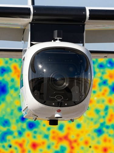
Leica Terrain Mapper
Our proprietary Leica Terrain Mapper 1 serves as the premier airborne LiDAR sensor for regional mapping. It penetrates dense tropical forest canopy to deliver high-density point clouds and flawless terrain models.
Operating at high altitudes, this system captures multi-directional views simultaneously, reducing flight times while multiplying data density for infrastructure planning.

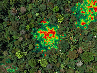
NDVI Vegetation Mapping
We leverage Red and Near-Infrared (NIR) spectral reflectance curves to monitor forest canopy health, calculate biomass density, and track localized deforestation with sub-meter accuracy.
This scientific approach translates raw spectral bands into actionable environmental intelligence, allowing land managers to detect early-stage vegetation stress before it becomes visible to the naked eye.
Sub-Meter Precision
±0.75 m
DSM & DTM Precision
19.3M Ha
Total Area Surveyed
21
Major Projects
Guaranteed technical threshold of ± 0.75 m for all digital surface and terrain models deployed in engineering projects.
Completed nationwide mapping coverage across challenging tropical terrains, logging over nineteen million hectares of high-resolution spatial data.
Successful large-scale geospatial deployments for government and enterprise clients across Southeast Asia, delivering certified spatial intelligence.